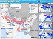
Natural Hazards
TOOLBOX
Filter
25
Featured
Language
Document type
No document type
18
Dashboards/Maps
6
Resource Platforms
1
Countries / Regions
Mozambique
8
Haiti
6
Nepal
3
Philippines
3
Malawi
2
Zimbabwe
2
Bangladesh
2
India
2
Afghanistan
1
Indonesia
1
Ecuador
1
Myanmar / Burma
1
Cuba
1
Pakistan
1
Authors & Publishers
MapAction
9
European Commission's Directorate-General for European Civil Protection and Humanitarian Aid Operations
3
UN Office for the Coordination of Humanitarian Affairs
2
UN Office for the Coordination of Humanitarian Affairs (OCHA)
2
CARE, Concern, CRS
1
et al.
1
Housing Recovery and Reconstruction Platform – Nepal (HRRP)
1
International Organization for Migration IOM
1
Ministère de la Santè Publique er de la Population, Haiti
1
Office for the Coordination of Humanitarian Affairs OCHA
1
Pacific Disaster Centre
1
UNEP
1
UNOSAT, International Charter Space and Major Disasters
1
World Health Organization, MapAction, Health Cluster
1
Publication Years
Category
Humanitarian Crisis
18
Statistics
2
Toolboxes
Maps
25
Cyclones Idai & Kenneth
8
Early Warning
1
Situation Reports & Updates
1
Resource Platforms
1

Damage Assessment of Muisne, Esmeraldas, Province, Ecuador (22 Apr 2016)

UNOSAT, International Charter Space and Major Disasters (2016) C1
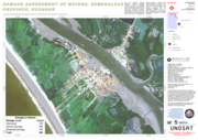
This map illustrates satellite-detected, potential damaged structures in Muisne, Esmeraldas Province, Ecuador. The analyzed area is located approximately 30 km north of the 16 April 2016 Muisne earthquake mainshock epicenter. This analysis is carried out using Pléiades satellite image acquired 20 A... more