Filter
70
Text search:
satellite
imagery
Featured
3
22
Language
Document type
35
19
5
4
3
2
1
1
Countries
6
5
4
2
2
2
2
2
2
1
1
1
1
1
1
1
1
1
1
1
1
1
1
1
1
1
1
1
1
1
1
Authors & Publishers
Publication Years
Category
19
15
2
2
Toolboxes
14
12
7
7
6
3
3
2
2
2
1
1
1
1
Camps is intended to help address the absence of public and standardized training resources for those seeking to use high resolution satellite imagery in support of refugee/IDP assistance operations
...
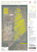
Analysis with WorldView-3 Data Acquired 07 March 2015
This map illustrates the IDP camp at the UNMISS Protection of Civilian (PoC) area adjacent to the UNMISS base in Bentiu, Rubkona County, Unity State, South Sudan. Using high-resolution optical satell
...
The Malaria Atlas Project (MAP) is a global research initiative that provides high-resolution, evidence-based spatial data on malaria transmission, risk and impact. MAP combines field data, satellite image
...

With an estimated population of about 5 million and an annual growth rate of 8 per cent, Dar es Salaam, Tanzania, is Africa’s fastest growing city.1 Over 70 per cent of the people live in informal, unplanned settlements with inadequate infrastructure. In addition, heavy rainfalls twice a year
...
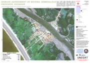
This map illustrates satellite-detected, potential damaged structures in Muisne, Esmeraldas Province, Ecuador. The analyzed area is located approximately 30 km north of the 16 April 2016 Muisne earthquake mainshock epicenter. This analysis is carrie
...
Today, WFP has the capabilities and know-how to tap into mobile technology and artificial intelligence to monitor food security; use satellite technology to locate and track communities in need; and offer digital finance via blockchain technology to
...
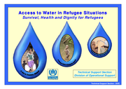
Survival, Health and Dignity for Refugees
Accessed March 13, 2019
Advocacy ,Social Mobilization ,Behavior Change Communications

2 march 2022
Today, the Commission is proposing to activate the Temporary Protection Directive to offer quick and effective assistance to people fleeing the war in Ukraine. Under this proposal, those fleeing the war will be granted temporary protection in the EU, meaning that they will be given a
...
Assessment in English on South Sudan about Education, Food and Nutrition, Drought, Epidemic and more; published on 22 Jul 2022 by IOM
This reference manual provides in-depth knowledge on the techniques, methodologies and best practices for using geospatial information in support of decision making for disaster risk management for specific hazards
This module carries pre-training entry level assessment as well as hands on exercise manual on Geographic Information Systems, Remote Sensing, Geographic Positioning System (GPS) and some applications of these technologies on Disaster Risk Management (DRM) especially for hazard mapping, monitoring a
...
The compendium compiles practical case studies on the use of Geospatial Artificial Intelligence (GeoAI) to enhance disaster risk reduction and emergency response across diverse geographic and institutional contexts.
The compendium features selected case studies submitted by twenty-seven Regional Su
...
The Atlas of health and climate is a product of this unique collaboration between the meteorological and public health communities. It provides sound scientific information on the connections between weather and climate and major health challenges. These range from diseases of poverty to emergencies
...
Between 1992 and 2012, disasters caused more than 1.3 million deaths, affected more than 4.4 billion people and led to US$ 2 trillion in economic damages and losses around the world. This Disaster Risk Management Strategy explains how the Agency for Technical Cooperation and Development (ACTED) anti
...
A public health emergency operations centre (EOC) is a central location for coordinating operational information and resources for strategic management of pugencies and events. EOCs provide communication and information tools and services blic health emer-
and a management system during a response
...
This book is aimed at policymakers in ministries of agriculture and national agricultural research institutes, as well as multilateral development banks and the private sector and provides guidance on various technology strategies and which to pursue as competition grows for land, water, and energy
...