Filter
3611
Filtered Results: 3611
Text search:
maps
Featured
Recommendations
396
New Publications
838
Language
Document type
No document type
1549
Studies & Reports
816
Guidelines
548
Manuals
298
Strategic & Response Plan
173
Training Material
90
Situation Updates
40
Fact sheets
37
Resource Platforms
24
Dashboards/Maps
20
Infographics
10
Brochures
4
App
1
Online Courses
1
Countries / Regions
Global
230
Western and Central Europe
90
Latin America and the Carribbean
66
India
66
Myanmar / Burma
63
Sierra Leone
57
Nigeria
56
Africa
52
Liberia
52
Ethiopia
48
Kenya
47
Congo, Democratic Republic of
47
South–East Asia Region
47
Syria
43
Nepal
40
Eastern Europe
38
Bangladesh
37
Ukraine
35
Malawi
30
South Africa
29
Asia
28
Rwanda
27
Guinea
26
Uganda
26
South Sudan
26
Ghana
25
Zambia
23
Mozambique
22
Haiti
20
Tanzania
20
West and Central Africa
20
Eastern Europe and Central Asia
20
East and Southern Africa
20
Middle East and North Africa
18
Philippines
17
Senegal
15
Western Pacific Region
15
Namibia
15
Brazil
14
Yemen
14
Indonesia
14
Afghanistan
13
Zimbabwe
13
Pakistan
13
Cameroon
12
Cambodia
11
Sudan
11
Russia
10
Somalia
10
China
9
Burkina Faso
9
Mali
9
Colombia
8
Thailand
8
North America
8
Vietnam
8
Tajikistan
7
Lesotho
7
North Macedonia
6
Turkey
6
Iran
6
Kyrgyzstan
6
Jordan
6
Lebanon
6
Botswana
6
Iraq
6
Madagascar
6
Moldova
5
Central African Republic
5
Chad
5
Serbia
4
Kazakhstan
4
Albania
4
Laos
4
Peru
4
USA
4
Sri Lanka
4
Ecuador
4
Eswatini/ Swaziland
4
Timor Leste/ East Timor
3
Chile
3
Burundi
3
Italy
3
Guinea-Bissau
3
Venezuela
3
Germany
3
Paraguay
3
Japan
3
Spain
3
Bosnia and Herzegovina
3
Côte d’Ivoire / Ivory Coast
3
Egypt
3
Georgia
3
Angola
3
Libya
3
Bhutan
3
North Korea
2
Benin
2
Gambia
2
Togo
2
Estonia
2
Uzbekistan
2
Vanuatu
2
Mongolia
2
Mauritania
2
Croatia
2
Saudi Arabia
2
Turkmenistan
2
Jamaica
2
Portugal
2
Azerbaijan
2
Belarus
2
Bolivia
2
Papua New Guinea
2
Djibouti
2
Romania
2
Palestine
2
Poland
2
Guatemala
2
El Salvador
1
Australia
1
Niger
1
Malaysia
1
Morocco
1
Qatar
1
Bulgaria
1
Armenia
1
Hungary
1
Maldives
1
Mauritius
1
Tunisia
1
United Kingdom
1
Israel
1
Southern Africa
1
Argentina
1
Greece
1
Solomon Islands
1
Authors & Publishers
Publication Years
Category
Countries
828
Clinical Guidelines
430
Public Health
319
Key Resources
295
Women & Child Health
271
Capacity Building
92
Pharmacy & Technologies
74
Toolboxes
HIV
249
Mental Health
226
COVID-19
224
Planetary Health
210
TB
208
NTDs
206
Rapid Response
129
Ebola & Marburg
122
Caregiver
120
Disability
118
AMR
117
Conflict
109
Global Health Education
96
2.0 Rapid Response
86
NCDs
74
Natural Hazards
73
Malaria
69
Pharmacy
58
Refugee
57
Zika
46
Health Financing Toolbox
42
Polio
32
Cholera
31
Specific Hazards
24
Social Ethics
3
Typhoon
3
South Sudan
2
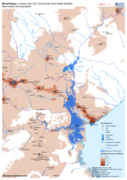
Map shows the population (based on WorldPop at 100m resolution generating through AI) and the Flood Extents known as of 19/20 March 2019 plus Health facilities
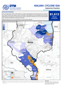
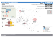
Since the beginning of March 2019, Malawi has experienced flooding and sustained heavy rain caused by the Tropical Cyclone Idai weather system. According to IOM Malawi, 81,613 households (HH) have been affected across four districts in the south of the country, specifically Chikwawa (12,755 HH), Zom...
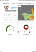
Situation en date du 23 Mars 2019
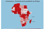
La carte est mise à jour quotidiennement
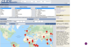
This interactive map shows polio cases and disease surveillance indicators worldwide within the desired timeframe and available data, as well as environmental samples in endemic countries.
Find out the latest information on polio this week.
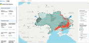
Ukraine Data Explorer
recommended
Please find here the latest updates
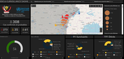
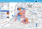
WHO/AFRO Ebola DRC Surveillance Dashboard
recommended
Interactive site with case data and a map of locations affected
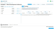
World Development Indicators (WDI) is the primary World Bank collection of development indicators, compiled from officially recognized international sources.
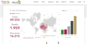
Ukraine Updates
recommended
Humanitarian Situation Updates
Accessing disaster information can be a time consuming and laborious task. Not only is data scattered but frequently identification of the disaster can be confusing in countries with many disaster events. To address both of these issues, Asian Disaster Reduction Center (ADRC) proposed a globally com...